Map Editor Suggestions
Welcome to the Map Editor's suggestion box!
This is the place to share your ideas for improving the Waze Map editor.
948 results found
-
Inserção de pontos de portaria e/ou guarda.
Seria interessante a inserção de pontos de entrada/saida de acessos lindeiros, portarias, guardas ou entradas de condomínios, Etc. Incluindo restrição de visitantes e horários de aceso autorizado.
1 vote -
Enable Undo-Button
Enable an Undo-Button for giving a wrong warning/hint.
1 vote -
Report wild animals on the live map
Report wild animals on the live map
The idea would be to report on the live map, about wild animals (whether: goats, foxes or any type) that the report lasted a couple of hours on the road, and over time reports and warnings could be made about the roads where there are more appearances.
This would be very good for secondary roads or mountain passes, in such a way as to create a warning if the route passes through an area that has a high level of reports of wild animals and the user would drive with more caution.1 vote -
Provide info of editor level nearby to help approve requests for changes
Provide help so business owners can have their place listed and approved
1 vote -
Could we add a bus feature for people who rely on public transportation?
Could we add a bus navigation feature for people who rely on public transportation?
1 vote -
import kml kmz files
suport import kml kmz files
1 vote -
Add a category for schools in the mobile app version of Waze
Please add school categories with icon on the mobile app
1 vote -
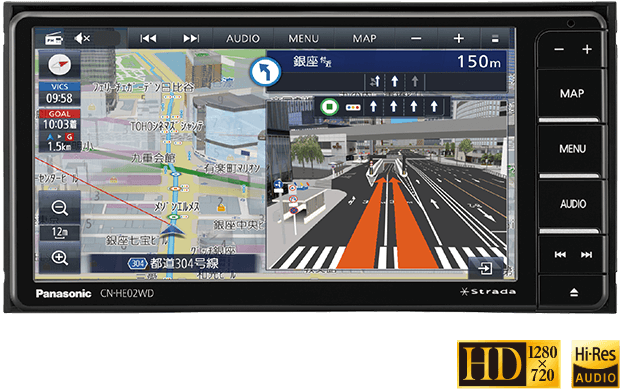
I would like to see a navigation function with detailed diagrams. (Since I am using a translation function, the text may be unnatural.)
nice to meet you. I am editing waze maps in Japan. I don't speak English so I use translation software. Therefore, there may be some parts of the text that are incorrect, so please forgive me.
Japanese car navigation systems have a function that displays a diagram that reproduces the shape of the intersection and which road to turn to when passing through an intersection or junction. However, that feature only supports some intersections.
It looks like the diagram on the right side of the screen in this image: https://panasonic.jp/car/navi/products/HA02_HE02/img/top/pic_01.png
Therefore, I would like to request that waze introduce such…1 vote -
you may improve
allowing us to decide if we want to see restaurants and their categories, hotels and petrol stations
1 vote -
Create your own navigation voice for in km instead of Miles
Create your own navigation voice for in km instead of Miles
1 vote -
Inserire una sezione dedicata direttamente nell’app di Waze in cui vengono inseriti tutti i dati dei viaggi precedenti velocità,traffico,ec.
La mia idea è quella di poter inserire una sezione facile e intuitiva direttamente nell’applicazione Waze per poter vedere tutti i dati inerenti ai viaggi precendenti, potendo vedere la velocità, possibili infrazioni, dati sul traffico e gli spostamenti dovrebbero essere visibili direttamente sulla mappa, sarebbe ancora meglio poter andare ad individuare tutti questi dati direttamente in un punto specifico del percorso, infine sarebbe opportuno inserire il resoconto completo di ogni singolo viaggio, spero di avervi dato un consiglio utile,
Gabriele1 vote -
Invisible RTC's and visible TBR's
Add the ability to control the visibility of TBR and RTC in the client (and define it in WME).
They say they often use the wrong type, just to match the required visibility.1 vote -
About adding a river in the waze editor
About adding a river in the waze editor
It takes a very long time to add a river
I think it would be easier if you could write a river as easily as you would write a road.
1 voteThanks for your feedback. At this time, this doesn't fit on our roadmap, but we'll keep it in mind for future product planning.
-
custom layers and map editor colours / themes
so I have used Waze for a bit and I love seeing the editor map with the coloured roads, but there's a few problems...
- no support in night mode
- can't change the colours, even if it's there to match the sign sometimes I want to have custom colours,
- can't have custom layers, sometimes I want to have the alternate route 1 in Melbourne Australia white or create my own custom routes. a layer I would like to create is a mobile camera colour where a road that has mobile cameras and such shows up as a custom…1 voteThanks for your feedback. At this time, this doesn't fit on our roadmap, but we'll keep it in mind for future product planning.
-
Allow users to keep hands on the keyboard until done typing
As a general principal of design, please allow the user to keep both hands on the keyboard until done typing information
Examples of desired behavior:
Places - After entering address, use the return/ enter key to activate the "apply" button. Or else automatically apply address changes when tab is used to advance to another field. (Currently, we have to move hand to mouse, click apply, find correct place on keyboard, and then use tab to advance to name field and resume typing)Closures - After entering description, use the tab key to advance to "direction" (Currently, this does not work).…
1 voteHey!
From our check, this should be working.
In case you still have an issues with it.Please open a bug, and we will take care of it.
Best,
Hezi -
modify navigation to Bombo Headland and Quarry
After recently speaking to sightseers looking for Bombo Headland while walking from Darien av I asked them what navigation tool they use. The name Waze came up. Sightseers navigating with Waze to Bombo Headland and/or Quarry are taken into Darien avenue, a residential street. I have recently successfully modified Google maps to direct navigation to the carpark at Bombo Beach which is the intended direction from Kiama council and is closer to these wonderful sightseeing places. Please see example here:- http://ow.ly/MBgg50DFXBp
1 vote -
Restricted areas: L5 users can restrict Rank 6 segments
With restricted areas, a level 5 (or Level X user depending on what the final level will be when released in production/country setting) could currently add a restriction to a level 6 segment.
Steps: find a rank 6 segment, draw an area on it => The segment is restricted.
This may be a WAD (similar to closures for people who have closure permissions), but it's still risky and lowers the protection of the rank system. If the user deletes the area restriction right after the map update, the problem cannot be identified without staff intervention.
Permalink: https://beta.waze.com/editor/?env=row&l ... =244207735
by:…
0 votes -
Implement reCAPTCHA v3
With the recent release of version 3 of reCAPTCHA (the thing you may get to see when you log in and the system suspects you may be a bot instead of a user), it would be a great idea to upgrade to the latest version. We've had several users who have had to fill in the CAPTCHA protection every time for some weird reason (I suspect someone in their neighbourhood is to blame), which could be alleviated with the new system. The system now gives you a score between 0 and 1 to gauge how trustworthy the request is. That…
0 votes -
Prefill city when using a street name suggestion
When we currently enter the name of a street, we get autocompletion suggestions based on existing roads in the neighbourhood. It would help quite a bit if the associated city field would also be filled in whenever we use one of these suggested road names. I know that every street has a city set (or none, on purpose) in the underlying data model, so this shouldn't be a big effort to add.
(see Mock up 1 + 2 attached )
I'm still contemplating whether I'll write a userscript for this or not. It's not so easy to hook into those…
0 votes -
Selecting a search result shouldn't reset the zoom level
When using the WME search box to find a road, it would be really nice if WME could leave the current zoom level well alone rather than always resetting it to level 3.
Even if it just defaulted back to level 4 that'd be an improvement, but jumping back out to 3 means we then always have to zoom back in at least one step if we want to be able to select a street segment. And even at L4, anyone looking to do some work on point places would then need to zoom in one step more before they…
0 votes
- Don't see your idea?